Energy


Featured Study: Assessing Solar Radiation for Optimal Distribution of Monitoring Networks
Incoming solar radiation, or irradiance, is a key attribute in sustainable energy resources research. Irradiance characterization via its spatiotemporal variability is important for siting of nodes in a network of solar energy monitoring stations (MS).
This study proposes an objective framework to optimize the deployment of MS over a sub-continental region. The framework comprises of a clustering analysis and a geostatistical analysis components to recommend optimal locations for MS placement according to a combination of geometrical, internal coherence, and geostatistical criteria.
About the Analysis
Satellite-derived solar irradiance data are initially submitted to a cluster analysis. The data are channeled through an Adaptive Affinity Propagation (AAP) algorithm to identify an optimal number of clusters in the region of interest. Each cluster defines a spatial area to be covered by one MS. The optimal number of clusters is derived through geometrical and statistical criteria, the clustering quality is measured through compactness and separation, and a validity index is further used for cluster validation.
Next, geostatistical analysis is employed to select the optimal positioning of the proposed MS in the clusters. The study examines 3 candidate spatial distributions, namely (A) the cluster centers, (B) the vector median of each cluster, and (C) random locations within a predefined distance range from each cluster center. Satellite solar irradiance data of derived Global Horizontal Irradiance (GHI) are split into a modeling subset and a validation subset. In a first (modeling) step, the modeling subset data are used as input to predict GHI at the proposed MS locations in each case A, B, and C. The predicted values at the end of the modeling step are used as assumed measured input at the MS locations for the following step. In the second (validation) step, GHI is predicted on a dense grid across the entire region at the locations of the validation data subset, and the validation data are used to compare the GHI prediction from each proposed MS configuration A, B, and C.
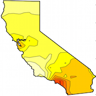
The satellite-derived GHI data are known to contain nontrivial uncertainty, hence the Bayesian maximum entropy theory is used to integrate rigorously the input data uncertainty in both steps of the geostatistical analysis. Separate prediction tasks are performed on the 1st day of each month in 2010 at sub-hourly 30-minute intervals during the daylight hours of the day. The following animated graphics illustrate the predicted GHI, measured in Watts per square meter, for the MS configuration A at 30-minute daylight instances between 6am and 6pm on June 1, 2010. The map on the left shows predicted GHI at the proposed MS locations in the modeling step, and the map on the right shows predicted GHI on a dense grid across California in the validation step. The GHI values range from 0 (very light yellow) to a maximum of 1100 (dark brown) Watts per square meter.


Following comparison with a few statistical measures, the study concludes that all 3 proposed configurations A, B, and C perform almost equally well. The results indicate robust cluster analysis that favors our AAP clustering approach, and the even performance suggests strongly coherent intra-cluster variance in each cluster. Bayesian maximum entropy perfroms space-time geostatistical tasks that would be otherwise unfeasible with classical geostatistical methods. Given the similar performance of the proposed configurations of MS locations through geometrical and statistical criteria, our framework further enables flexibility to select MS locations on the basis of additional criteria such as geographic and terrain conditions, and financial considerations.
The study is a complete proof-of-concept approach on a space-time scale (i) to assist in the deployment of large-scale solar projects, and (ii) that is suitable for applied renewable energy research, which typically takes place in spatially state-wide domains and in sub-hourly temporal intervals.
Reference
Zagouras A., Kolovos A., and C.F.M. Coimbra. 2015. Objective Framework for Optimal Distribution of Solar Irradiance Monitoring Networks. Renewable Energy. 80, pp.153-165.